Drone inspection

Safe inspections of buildings, installations and hard-to-reach locations

Want to inspect a building, installation or infrastructure without unnecessarily exposing people to risks? With a drone inspection, we capture hard-to-reach and high-risk locations safely and efficiently. With the right drones, cameras and sensors, we detect damage, deviations and technical issues without always needing scaffolding, aerial work platforms or physical access.

You receive clear images and useful reporting for targeted maintenance, repairs or further inspections.

What is a drone inspection?

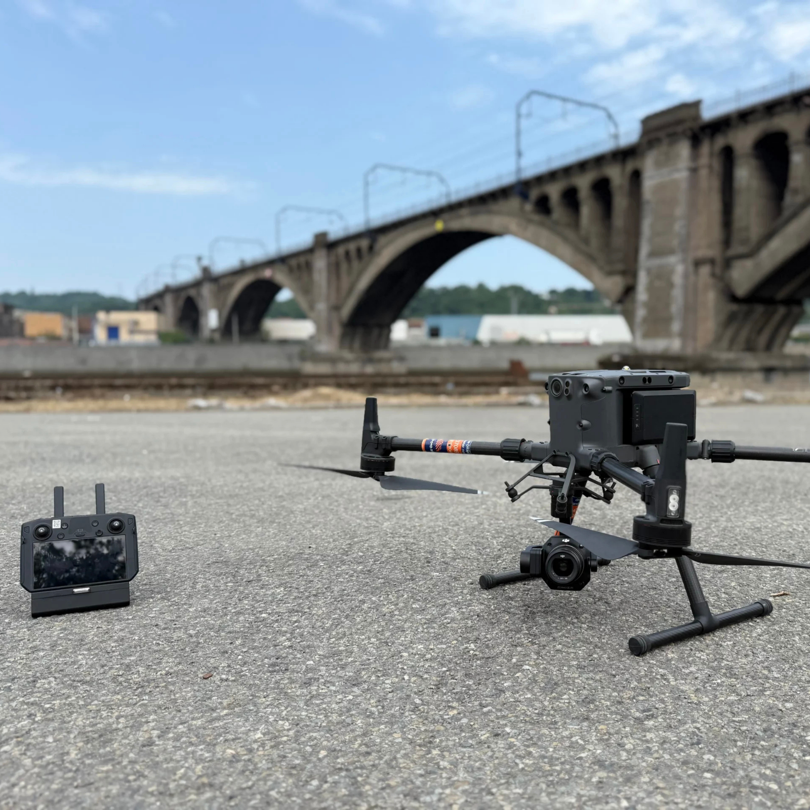
During a drone inspection, we deploy specially equipped drones to safely inspect hard-to-reach, confined or high-risk locations. For industrial environments, we use indoor drones, among others, which can fly close along walls, installations and structures.

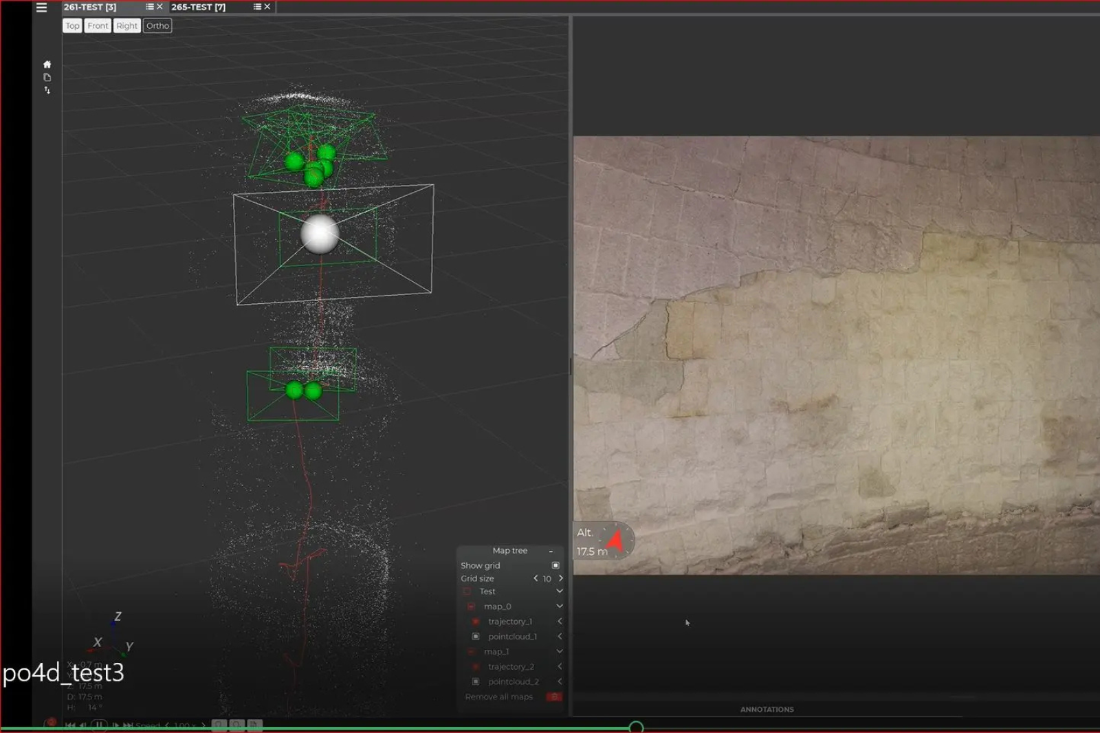
This allows us to clearly capture damage, wear and other deviations. Where relevant, we supplement the images with reporting or 3D visualisation. The focus is on safe inspection and gaining insight into the condition of a location, not on traditional geometric surveys.

Do you need accurate survey data? Then TOPO4D can help with drone surveys and drone mapping, where we map sites and process the collected data into usable survey products. To map riverbeds, depths and underwater structures, we use bathymetry.

Verwerking van drone-inspectiebeelden in gespecialiseerde software, met puntenwolk en gedetailleerd close-upbeeld van een gescande muur.

The benefits of a drone inspection

A drone inspection offers many advantages over traditional inspection methods. Because no scaffolding, aerial work platforms or physical access are required, the inspection is safer, faster and often cheaper, while still giving you a complete and clear picture of the condition.

  • Safety: hard-to-reach, high or confined spaces can be inspected without an inspector having to physically enter a high-risk environment.
  • Efficiency: with a drone, large surfaces and complex structures can be inspected from different angles in a short time.
  • Cost savings: many inspections do not require scaffolding, aerial work platforms or other extensive access facilities. This reduces preparation and can lower the total inspection cost.
  • Fast decision-making: you receive clear visual documentation of the condition at the time of inspection. These images can be used to plan maintenance, repairs or additional inspections in a targeted way.

What can a drone inspection be used for?

Buildings and infrastructure

A drone inspection of buildings makes it possible to safely inspect roofs, facades, chimneys, bridges and other hard-to-reach structures. Damage, wear or deviations quickly become visible, without always needing scaffolding or aerial work platforms. A drone can also be deployed on construction sites when access is difficult or there are stability risks.

Industry and petrochemicals

In industrial and petrochemical environments, we use drones to inspect tanks, pipelines, production installations and other technical infrastructure. A drone inspection helps to detect corrosion, damage and other deviations in time, so that maintenance or further inspections can be planned in a targeted way.

Sewers and confined spaces

A drone inspection of sewers makes it possible to inspect sewers, culverts, tunnels and other confined spaces from the inside. Specialised indoor drones reduce the need for human access and can also capture hard-to-reach sections. This makes the inspection safer and often more efficient than with traditional inspection methods.

Energy and utilities

Drones are used to inspect solar panels, wind turbines, pipelines and other energy infrastructure. This gives maintenance teams quick insight into the condition of installations and allows them to detect potential problems earlier.

Need a location inspected?

Tell us what you want inspected, and we will look at which drone and inspection method suit it best and send you a tailored quote.

Thermal drone inspection

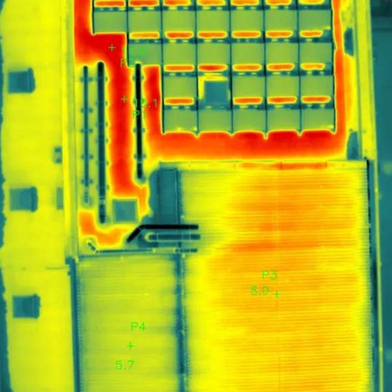
With a thermal drone inspection, we visualise temperature differences in buildings, solar panels and technical installations. A thermal imaging camera reveals deviations that cannot always be detected with the naked eye.

This allows us to detect heat loss, thermal bridges, overheating and thermal anomalies, among other things. The images help to investigate potential problems further in a targeted way and to plan maintenance more efficiently.

For a broader analysis of heat loss and temperature differences, you can also make use of our thermographic inspections.

Thermografische dronebeelden van een plat dak met zonnepanelen, waarop temperatuurverschillen en meetpunten zichtbaar zijn.

How does a drone inspection work?

01

Analysis

We start with the location and your inspection question: what needs to be inspected, which zones and risks are involved and what information do you need? This way, we choose the right drone, sensor and method.

02

Preparation

We assess the on-site situation in terms of safety, accessibility and regulations. Are permits required? Then we take care of them.

03

Capture

Our pilot captures the agreed zones in a targeted way. During indoor inspections, you can watch live, so that suspicious areas can immediately be examined more closely.

04

Data processing

We organise and analyse the images: from photo and video to thermography or 3D visualisation.

05

Delivery

You receive the results in a usable format, if desired as a report with images and points of attention. This way, you can immediately see where inspection, maintenance or repair is needed.

Some of our projects

Curious what a drone inspection looks like in practice? In the projects below, you can discover how we use drones to inspect buildings, installations and hard-to-reach or high-risk locations.

How much does a drone inspection cost?

The price of a drone inspection depends largely on the location, the type of inspection and the technology required. For a simple visual drone inspection, you can usually expect a few hundred euros. For more complex industrial, indoor or thermal inspections, the price can be considerably higher.

The cost is determined by factors such as:

  • the size and complexity of the location
  • the accessibility of the zones to be inspected
  • the type of drone, camera or sensor
  • visual or thermal inspection
  • any permits and safety measures
  • the required analysis and reporting

An exact price for your drone inspection?

The price depends on the location, accessibility, scope and type of inspection. Without that information, we cannot determine a correct price. That is why you always receive a quote tailored to your project.

This is why clients choose TOPO4D

Tailored technology

Every inspection requires a different approach. Depending on the environment, the risk and the required level of detail, we deploy the most suitable drone, robot, camera or sensor.

Experience in construction and industry

As expert land surveyors, we have extensive experience on construction sites and in industrial environments. This technical background helps us to carry out inspections correctly and interpret the results clearly.

Safe and compliant

Our drone inspections comply with European aviation standards. For more complex operations, we have the right expertise and SORA approval where required.

Usable results

We convert the collected images and data into a clear deliverable. If necessary, we supplement it with an inspection report with concrete points of attention for further follow-up.

They went before you

Peter De Schrijver
"Ik ben ontzettend tevreden over de diensten van TOPO 4D en zaakvoerder Guillaume Vanden Avenne. Guillaume maakt altijd correcte afspraken en komt deze ook stipt na. De prijzen zijn zeer correct en transparant, zonder verrassingen achteraf. Zijn kennis en expertise in het vak zijn indrukwekkend; hij is echt een krak in zijn vakgebied. Bovendien is hij altijd op de hoogte van de nieuwste methodes en technieken. Ik kan TOPO 4D van harte aanbevelen aan iedereen die een betrouwbare en deskundige landmeter zoekt!"
Jonas Van Vaerenbergh
"Zeer goed landmeetkantoor die up-to-date is met alle innovaties op de markt. Guillaume is een uitstekend dronepiloot en bracht alles mooi in beeld. Dankjewel Topo4D voor het geleverde werk!"
Denis Zhilkin
"Excellent and professional job done. I would also like to note that all work was completed in the shortest possible time."

Frequently asked questions about drone inspections

How long does a drone inspection take?

The duration depends on the size and complexity of the location, the number of zones to be inspected and the type of inspection. For a simple, small-scale inspection, half a day is often sufficient. Larger or industrial sites may require more time.

Wind, precipitation and visibility affect an outdoor drone inspection. We monitor the weather conditions and schedule the flight at a moment that is safe and technically feasible. For indoor inspections, weather conditions obviously play no role.

Yes. By inspecting the same building, installation or infrastructure again at fixed intervals, you can compare images from different periods. This makes changes, new damage or further wear more visible and allows maintenance to be followed up in a more targeted way.

Not always. In certain situations, an inspection can take place while a site or installation remains operational. Whether this is possible depends on the environment, the safety regulations and the type of installation. We assess in advance which approach is safe and feasible.

That depends on the environment and the type of inspection. Sometimes it is sufficient to provide access to the location, while industrial or complex sites may require additional safety measures. We agree in advance on what is needed on the day of the inspection.

Have your location inspected by drone

Would you like to have a building, roof, solar installation, tank, sewer or technical installation inspected? Tell us what you want to have checked. We will look at which inspection method is most suitable and send you a tailored proposal.

"*" indicates required fields

Name*
Address or site location
Drop files here or
Max. file size: 256 MB.
    Scroll to Top